Showing posts with label sight by walk. Show all posts

Crossing 'Tropic of Capricorn' Line over Botswana

Crossing 'Tropic of Capricorn' Line over Botswana
Mahalapye : Central District : Botswana

Tropic of Capricorn is one of five important geographic latitudinal circle across the Earth, which is 23.5 degree South of the Equator. The opposite line of Tropic of Cancer at Southern Hemisphere. The southern most point of Earth, where sun rays directly at local noon. According to Wikipedia:

"The Tropic of Capricorn is one of the five major circles of latitude that mark maps of the Earth. As of 22 March 2016, its latitude is 23°26′13.9″ (or 23.43718°) south of the equator, but it is very gradually moving northward, currently at the rate of 0.47 arc seconds, or 15 metres, per year."

This important geographical line has crossed through Three Oceans: The Atlantic, Indian and Pacific Ocean as well as ten countries across the continents from South America toward Oceania. These countries are:

1. Chile, 2.Argentina, 3. Paraguay, 4.Brazil, 5. Namibia, 6. Botswana, 
7. South Africa, 8. Mozambique, 9. Madagascar and 10. Australia. 


Tropic of Capricorn Road Mark
Travelers will find monuments, marks or road sign while crossing this line over the regions of the above mentioned countries.I had an opportunity to cross this line twice over Botswana. Tropic of Capricorn Line is crossed over three places at Botswana, including Kalahari desert. These places are: Khutse Game Reserve, Khule and Mahalapye. 


Monument of Tropic of Capricorn. Photographer: Umme Habiba Jasmine

Monument of tropic of Capricorn : Angular view 01

Tropic of Capricorn monument frontal angular view.
Botswana's only monument on this line is situated near Mahalapye, just beside the A1 Highway. The monument made beside the road. There is a tube stand  affixed on the top of the monument. There are two plates of wrought iron, attached to this markup monument. its very simple monument, just like a geographical benchmark.s There is a little description about this monument is inscribed on plates in English and Setswana. 
Here is the English version:


"THIS POINT IS ON THE TROPIC OF CAPRICORN, WHICH IS THE MOST SOUTHERLY LATITUDE REACHED BY THE SUN. HERE THE SUN WILL BE AT THE ZENITH EACH YEAR ON MIDSUMMER DAY AT MIDDAY LOCAL APPARENT TIME WHICH IS ON 22 DECEMBER AT APPROXIMATELY 12 MINUTES PAST TWELVE O' CLOCK NOON AT THE TIME THE SUN WILL SHINE DIRECTLY DOWN THE TUBE ABOVE THE NOTICE"

This is the first time I have seen such type of monuments. Its a very simple monument but I like it for the information, geographical value.24-08-2015
 ____________________
Geographical Coordinate: 23° 29' 58.41" S  26° 36' 48.75" E

Sight By Walk: "Bibi Mariam" The Cannon of Mir Jumla

Sight By Walk: "Bibi Mariam" The Cannon of Mir Jumla
Osmani Park : Gulistan : Dhaka : Bangladesh

At present there are some cannons at Dhaka National Museum, but you have to buy tickets to see those medieval warheads. Only one gorgeous and giant cannon is out of museum and install in a public place- The Bibi Mariam


Front Side: 20th July, 2012[Panoramio
Rare Side: 10th July, 2013
Bibi Mariam cannon is a fascinating war-piece. It has a fascinating history as well long time attachment with Dhaka City. It is part of pair cannons made by Dhaka's local blacksmiths under the supervision of Mughal arm designers. The other one of the pair was titled after male name as  'Kaley khan Jam-Jam' . Bibi Mariam is smaller than the Kaley Khan Jam-Jam. These two cannons were used to keep the Mogh and Arakanese pirates away and secure the waterway e.g. the Buriganga during Mughal era. These two were the best gun of Mir Jumla's Arsenal. Mir Jumla was the Governor of Mughal Dhaka since 1660-1663. Bibi Mariam was used and travelled a great deal of annex Mughal Empire upto Kamprupa of Assam. later the pair was brought back to Dhaka. Kaley Khan was vanquished by river erosion since 1832 somewhere between todays Sadarghat and Zinzira area. Since then Bibi Mariam is placed in different places around the Old part of Dhaka City:Chawkbazar, Sadarghat, Gulistan and lastly now at  South Gate of Osmani Udyan[Osmani Park].


"Bibi Mariam is 17’-6” long,  maximum outer diameter at rear is 2’-2” and at mouth 2-6” with 6"dia. barrel hole (inside dia)". The cannon is made of wrought iron. Barrel of the cannon is conjuncted of three separate tubes. 
_____________

In Google Map | British Library | Dhaka

Sight By Walk : Nandail Tank of Kalai

Sight By Walk : Nandail Tank of Kalai
Nandail : Punot : Kalai : Joypur Hat : Bangladesh

Introduction

Kalai[কালাই] is an upazila of Joypurhat[জয়পুরহাট] District of Bangladesh,which is famous for cultivating potato, rice and various spices. The place is situated between Joypurhat and Bogra. It is a nice plain land of Barind[বরেন্দ্র] Tract. This place is significantly important for Joypurhat District, because the largest tank of district is located here at Nandail[নান্দাইল] village.


Series of Acacia Tree on the bank of tank [ Panoramio
Nothern part from from Southern edge
Series of trees
Nandail Tank/ Dighi/ Deeghi

There is a man made tank situated at Nandail village of Punot Union of Kalai. I took a Sight By Walk around that huge tank few day ago and experiences to see some nice scene and calm environment as well as local biodiversity based on that vivid pond. People of Kalai feel proud and believe this tank is the only tourist attraction of their Upazila.


Nandail Tank is locally known as Nandail Dighee [নান্দাইল দীঘি], a man made rectangular shape tank or reservoir for the vicinity. This huge tank is the main source of irrigation and fish culture of Nandail Village, as I find no notable channel for natural irrigation is there for such farming and cultivating village.  Some four habibat of Nandail is surrounding this huge tank. 


Small pit for boats


A broken boat is waiting to be fixed up.

History, Myth and Facts

Entire tank is roughly 952-55 meters long and 230-242 meters wide, acquiring total volume of 59.40 acres{0.24 square kilometers}. It is said that the local raj Nandalal was the mastermind to dig up this tank in 1610. Another common myth about this tank that is- tank was dug out in one night. This is a governments property now, local government leases this tank for fish farming every year. The tank is surrounded by several series of trees, including palm,coconut, acacia, mango, mehgoni and some other species, and lot of aquatic plants at banks. There are many snakes, few otters, fresh water frogs and domestic ducks always be seen. Checkered Killback (Xenochropis piscator) is very common species at there.  This huge tank is the home for many migratory birds in winter season.
There is a college and a local library by the name of this tank is established at the southeast corner of this  tank.


Nandail Dighee College
Northern View [Panoramio]


A chekered killback is swiming.

Time to visit

This nice place can be visited any time of year. To see the migratory bird, November to February is the best time of year to go there. Morning and evening view of this tank and its surrounding is very scenic. Sunset at Nandail is more beautiful as my following photos shows:

Awesome Sunset at Nandail Tank 1
Silhouette effect  of sunlight on the water
Series of palm trees beside the tank[Panoramio]
Awesome Sunset at Nandail Tank 2
Awesome Sunset at Nandail Tank 3
Awesome Sunset at Nandail Tank 4 [Panoramio]
Awesome Sunset at Nandail Tank  5

There is no hotel at Nandail village, travelers have to stay at Kalai Municipality Area. It takes 15-20 Taka per person from Kalai to Nandail bustand before Punot Hat busstand by local vehicles : Nosimon , BatteryTrikes are also available to go near tank directly from Kalai. Tourist can take rickshaw or van to go Nandail village from bus stand, I did not wait for any rickshaw, I walked in to see the road side village scenery. 
Travellers can come to Kalai via bus or by train via Joypur Hat. Have a safe Journey. 

Here is the Google Map Location : Nandail Tank on Google Map

Remembering War Heroes at Maynamati War Cemetery

Remembering War Heroes at Maynamati War Cemetery
Maynamati : Comilla : Bangladesh

Prologue
Recently I have few times to roam to the middle Eastern part of Bangladesh, in this hectic schedule. I revisit some of my old day traveled places, like many other tour I miss my camera to take some good snaps around, but did not delay to collect my clicks by others cellphone VGA cameras. This time I pay homage to the World War II heroes, visiting the War Cemetery at Maynamati, Comilla.

From Panoramio
Background
According to CWGC the historic background is given as-
"Before the war Maynamati was a hamlet of a few dozen huts, but during the war a large military camp was established there. Several ordnance depots and a number of military hospitals, both British and Indian, were in the area, including Nos. 14 and 150 British General Hospitals; and the majority of the burials in Maynamati War Cemetery were from the various hospitals. Graves from isolated places in the surrounding country, and some from as far afield as Burma, were moved into the cemetery by the Army Graves Service and later on by the Commission; and it was found necessary to transfer also graves from small cemeteries at Dacca, Faridpur, Paksay, Saidpur, Santahan and Sirajgany, where they could not be maintained.


Under a canopy of indigenous flowering and evergreen trees such as teak, gold mohur or flamboyant and mountain ebony -- serene, sombre and peaceful -- dominated by a small flat-topped hill, lies the graves of 737 soldiers.[Mysyed]  


The cemetery was started by the Army and laid out by the garrison engineer. It is dominated by a small flat-topped hill crowned with indigenous flowering and evergreen trees. Between the entrance and this hill lie the Christian graves, and on the far side of it are the Muslim graves. On a terrace about half-way up the hill, facing the entrance, stands the Cross of Sacrifice, and on the other side a shelter looks over the Muslim graves to a tree-framed view of the countryside beyond.

This place is quite calm,there is  no hassle around. CWGC mentioned that there are some 700 hundred casualties engraved here, exact figure is 737.

Other Trivia 
Most of the war heroes are young soldiers within the age range of 18-25 of  various religions, while civilians around 40. A large cross make the center piece  of this grave yard. This is the second World War II, graveyard in Bangladesh, other one is situated in Chittagong. Muslim casualties are graved on the mound of the grave yard. This cemetery is the rare place which have the grave of Jews. 23 unknown soldiers has been buried here. Each tombstone of marble and mosaic carries the name of the deceased and some information about the origin of the person and the regiment he belonged to. In this cemetery lie the bodies of British, African, Indian, Australian and Japanese.


Google Map | Commonwealth War Graves Commission

Amazing Wave Bridge : Henderson Waves

Amazing Wave Bridge : Henderson Waves
Henderson Road : Singapore


Recently another amazing attraction of Singapore caught my eye, I stumble upon this walk way. Despite of popular infinity pools of Marina Bay Sand, this bridge is amazing:
Henderson Waves (亨德森波浪桥)) is a 274-metre (899 ft)long pedestrian bridge. At 36 metres (118 ft) above Henderson Road, it is the highest pedestrian bridge in Singapore. It connects Mount Faber Park and Telok Blangah Hill Park. It was designed by IJP Corporation, London, and RSP Architects Planners and Engineers (PTE) ltd Singapore.The bridge has a wave-form made up of seven undulating curved steel ribs that alternately rise over and under its deck. The curved ribs form alcoves that function as shelters with seats within. Slats of yellow balau wood, an all-weather timber found in Southeast Asia, are used in the decking. The wave-forms are lit with LED lamps at night from 7pm to 2am daily.[Wiki]


The 1,500 square meter timber deck sitting on top of the steel structure is the centrepiece of the project.The complex, doubly-curved portions of this large expanse of tropical hardwood form a tapestry of 5000 modular boards, each varying by a single degree every 10m –and many tapered to measure. The entire deck being supported on a steel sub-frame with vibration dampeners, the coordination of steel and timber became a challenging task. Using its proprietary equations, the architect issued precise numerical descriptions of the surface at regular 500mm intervals, and provided dimensional coordinates that greatly assisted the production of the timber manufacturer’s shop drawings.[Source]


Here is a youtuve video of this bridge, by Jawker :


Geo Tag: Google MaP | Bing Map

Ali Amjad Khan's Clock Tower : Oldest & First in Bangladesh

Ali Amjad Khan's Clock Tower : Oldest & First in Bangladesh
Chandnighat : Kotwali : Sylhet : Bangladesh

I find so few tourist who did not see the singular clock tower crossing the Kean Bridge of Sylhet. Most of them notice it properly or at least stare at it once. Clock tower is not an interesting thing to watch with attention to many people world wide; but it is really a rare tower in Bangladesh. Again, there is no Big Ben in Bangladesh; but many urban dwellers of Dhaka and Sylhet may disagree that a clock tower is not so interesting subject to write blog about it. To me, Ali Amjad's clock tower is a special one and clearly distinctive from the other two of Dhaka's DIT and Nagar Baban towers(see picture 1).

Picture 1: Clock towers of Nagar Bhaban and Dhaka DIT, now RAJUK
Ali Amjad's Clock Tower
Ali Amjad's* clock is a popular attraction of Sylhet City. Situated on the Northern bank of the Surma river at Chandnighat, down left to another most 'talk-about' subject - the Kean Bridge. This is the oldest and first clock tower of Bangladesh, as well as a singular genre. Ali Amjad Khan, a Nawab of Prithimpassa, built this tower. 
At far sight, one can easily presume it as a church, because of its structure. I wonder what was the color of corrugated sheets at the early days. I find the architecture  of it is also interesting  Tower is standing one an octagonal base, clock chamber is rectangular and lastly the crest of tower is a triangular pyramid.  

Picture 2: Ali Amjad's Clock Tower and the Kean Bridge
Picture 3 : Ali Amjad' s Clock Tower, from Ali Nasir Khan
Unlike other two dials this is not a part of a big building, it is build only to be a clock tower, and this is the best distinctive feature of this clock tower with others of Bangladesh. The clock is now active after a long time break. District Council of Sylhet maintains and provide mechanical support, these days. 

Background of This Clock
I guess, Ali Amjad was a philanthropist and had good taste to build this tower. But exactly since when this clock has been start ticking, I could not find out. I did ask the local people about the history, unfortunately Sylhety dialect was really more than Greek to me. I have dilemma about the exact story behind building this tower. Perhaps the following two sources could provide idea about the background story-
According to Nawab's family web, the clock was presented by Ali Amjad's father Nawab Ali Ahmed Khan, which he was later constructed around 1895(1301 Bangla Calender). Another source+,Ali Amjad was invited to see Delhi and thereby charmed by the clock made with the instigation of the princess of Delhi. He also craved to build the same and eventually made it with the similar design & pattern. 


Whatever the history is, I find this clock unique and notable attraction to write about.
-----------
Picture Source: RAJUK and Nagar Bhaban,from Banglapedia | Wikipedia
Geotag: Google Map
*[alternatively pronounced as Ali Amzad ;and mistakenly Ali Amgad]

Atiya Masjid : Retrospective to Shah Baba Kashmiri

Atiya Masjid : Retrospective to Shah Baba Kashmiri
Atiya : Delduar : Tangail : Bangladesh

Atiya masjid is one the impressive architecture of 16th century in this region. it is famous for its exceptional terracotta decoration, the blends of local Bengal art and Mughal crafts. Atiya Masjid was founded in honor of Shah Baba Kashmiri, a saint from Kashmir Region. Shah Baba Kashmiri's  name is a related subject with this Masjid. But he always lives in the shadow of this famous Mughal era erection. 


Me and my friends went to Atiya again in last 29th April. This time I stayed longer than my previous visit. We found out the place of Shah Baba Kashmiri, this time. The place is not a special, but it is situated in few step distance from the masjid. Though it is in closest vicinity of masjid compound, but tourist pay a rare visit to this place. Here it is, the possible place -


The place is a one domed building, having only one chamber inside; standing so close a to a detached lake of Lauhajang River.It stands on the North-West direction from the Masjid,  just 100 steps away, beside the main road. This building is now a center place of the primary school  of Atiya. There are squared building  four pilers. I believe this building was also equally decorated like the Masjid. Trees and roots on the roof covered this building as the silent witness that this place was not habitable for a long period.
---
Photo Curtesy : Sarwar Hossain and Tanjir Mahmud Real
More low resolution photos of this tour is posted in Facebook page 
---
Previous Post  > Atiya Masjid : 4 Century Old Architecture|Google Map

Hussaini Dalan : Oldest Shiite Shrine of Dhaka

Hussaini Dalan : Oldest Shiite Shrine of Dhaka
Dhaka : Bangladesh

Hussaini Dalan(sometimes reffered as Husaini) is an imambara -center for Shiite(the followers off Shia Islam) in the old part of the city of Dhaka, attributed to the Mughal Period.  The building seems to have been originally erected (in 1642 AD) by one Sayyid Murad during the governorship of shah Shuja, who, although himself a Sunni, was eager to preserve and patronise Shiite institutions. Traditions relate that Sayyid Murad, having seen al-Husain in a vision erecting a tazia khana (house of mourning), was inspired to raise the building, which he named Husaini Dalan. The original building may have been a small structure, expanded to its present form in later times. The east india company repaired it in 1807 and 1810, and a portion of the building was reconstructed after the earthquake of 1897.

1990's ; Taken by Md Johir Uddin for Banglapedia
The building stands on a high platform ascended by a flight of steps on the east and consists of two main halls placed back to back. The shirni hall, facing south, is coloured black to indicate sorrow and mourning for the death of al-Husain, and the khutba hall, facing north, has a mimbar with seven wooden steps. In the latter hall are hung several religious symbols. To these halls have been added subsidiary halls in two storeys on the right and left, probably meant for women. The southern facade of the building is flanked by two three-storey polygonal hollow towers, crowned by domes. The parapet of the building consists of coloured merlons, and over its four corners are four kiosks. The building as a whole gives a modern appearance with remnants of older architecture here and there.

2010-05-09 ; Prothom Alo

 The main building “Hussaini Dalan” is situated in the middle of complex, built on an area of about  (9,380 Sq. ft/ 88.05 Sq. Meters). In the south touching the building there is a “Pond” having an area of 1.01 Bighas (14,544 Sq. ft/ 1376.95 Sq Meters). This pond is the main attraction of this building which touches the walls of Hussaini Dalan.
1904; from the British Library by Fritz Kapp
Official web of this ancient monument provide the following description of this architecture, which may be interesting for knowing about an interior of a Tazia Khana(house of mourning):

The main building is two storied. The ground floor is hollow having graves in the northern portion beneath the 1st floor. The 1st floor has two big Verandahs one in the south with four pillars (Round Shape) and another in the north with four pillars (Square Shape). The two big hall rooms and between the two verandahs each measuring (1,430 Sq. ft/ 13.54 Sq. Meters and 935 Sq. ft/ 88.5 Sq. Meters) are utilized as “Prayer Room” and “Zari Khana” (Where the memory of Imam Hasan & Hossain (A.S.) Zari with Alam are kept). The prayer room is utilized for “Namaz-e-Panjgana, Namaz-e-Jumma and Majlises” (Large Mourning Gatherings). Majlises (Gathering) on the Shahadat Dates (The Dates of Martydom of Imams (A.S.) Rasul Akram (S.M.) and Hazrat Fatema Zehra (Salawatullah Alaiha) etc.) are held in the “Zari Khana”.

There are three more rooms in the first floor. One is called “Huqqa Khana” (289 Sq.ft/ 27.4 Sq. Meters) adjacent to prayer room is used for keeping precious items of Imambara. The room adjacent to the southern verandah is called “Nishist Gah” (340 Sq. ft/ 32.15 Sq. Meters) or sitting room where officials of Hussaini Dalan Imambara used sit and hold their meetings. The Naib Nazims also held their meetings. The Naib Nazims also used to sit in this very room in the olden days.

The main building has two stair cases one quite large in the east which is utilized as the main entrance to the Dalan and the other in the back (West) which is small and used by the Khadams etc. Recently a new small staircase in the north-west has been built for ladies.

Just above the “Huqqa Khana” there is a small room which is called “Bala Khana” (The place of the ladies) about (360 Sq. ft/ 34 Sq. Meters) from where the ladies used to hear   watch majlises from the holes in the wall just above the “Zari Khana”.


Compiled from Banglapedia | Official Web | Wikipedia

Dubalhati Rajbari : A Ruined Palace

Dubalhati Rajbari : A Ruined Palace
Bangaon : Dubalhati : Naogaon : Bangladesh

'Rajbari' means king's palace, in Bangla. Dubalhati Rajbari was originally the residence of the Maharajas of Dubalhati. About 53 Rajas and Jamindar(lanlords) ruled this place, governed from this palace. A feeder road through Deghoi Beel started from Naogaon Fisheries end, about 5.70 kilometers from Naogaon, provide the access to the palace area. 

Raja Harendra Ray Chaudhury  constructed the main fabric of this palace during the Pala Dynasty (750-1174). The architect of this palace is changed  from time to time, is now a ruined place, standing tall as an evidence of monarch of that area. The palace has been destroyed by the Pakistani army during the war of independence in 1971. Present foundation is a rebuilt construction after the devastating jolt in 1897.  


This palace blocks accommodated sleeping chambers, a Darbar(reception) hall, one dining hall, private theatre, prayer hall, guest house, stable and attendants quarter and a conference hall.  Northern facing of the palace presents facades and long masonry columns vows the test of king and fondness Greek style architect. A plastered motif is still there, hanging on the internal entrance of palace. A turret is survived the destruction of weather. Few  panel of terracotta is still there sticking on the wall. The palace was three storied building(first photo), now remain two floors left for further decay.


The entire palace area is surrounded by four ponds, in addition there are some six enormous tanks centering the palace. Most of these ponds were built for irrigation and supplying fresh water during the famine in 1874. There is a bazar (marketplace) in the vicinity of the palace. Probably archeology department has no budget for reconstruct this palace.
.................
Wiki's Description | Google Map | Google Earth
Photo Courtesy : Badiuzzaman Tamal 

Nayabad Masjid : Vestige of Mughal Architecture

Nayabad Masjid : Vestige of Mughal Architecture
Ramchandrapur: Kaharole: Dinajpur: Bangladesh
Introduction
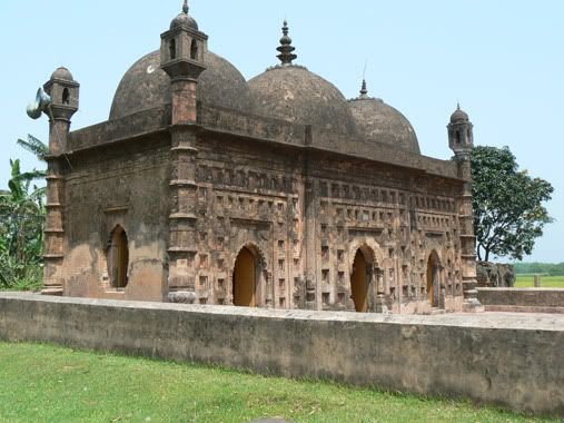
Nayabad Masjid is an architectural vestige. which was built just after the  erection of  Kantanagar Temple. According to local traditions, the mosque was built by Muslim architectural workers who had come to this place from the west to build Kantanagar Temple sometime in mid-18th century. They had settled in Nayabad, a village near the temple, and had built the masjid for their own use.


Before Renovation From Banglapedia 
Location
The masjid is situated on the bank of the Dhepa river in village Nayabad in Ramchandrapur Union under Kaharol Thana of Dinajpur district, about 20 km to the north-west of the district town. The mosque, built on about 1.15 bighas of land, has been renovated by the Department of Archaeology, Bangladesh.


Construction Period
An inscription on the central doorway records the date of its construction as 2 Jyaistha, 1200 (Bangla Calender) (1793 AD) in the reign of Mughal Emperor shah alam II. According to local traditions, the mosque was built by Muslim architectural workers who had come to this place from the west to build Kantanagar Temple sometime in mid-18th century. They had settled in Nayabad, a village near the temple, and had built the mosque for their own use.


Photo by Tanzirian
Architect
It is an oblong three-domed mosque with octagonal towers at the four corners and measures 12.45m ´ 5.5m externally. The walls are 1.10m thick. Of the three arched entrances the central one is bigger than the flanking ones. These are equal in height and width. The central arch is 1.95m high and 1.15m wide. There is an arched window each on the south and north sides. Multi-cusped arches have been used in the doorways and windows. There are three mihrabs inside in the western wall in line with the three entrances. The central mihrab (2,30m high and 1.08m wide) is bigger than the flanking ones which are of equal size. Three hemispherical domes cover the mosque, of which the central one is bigger than the side ones. Pendentives have been used in their phase of transition. The parapet and cornice are straight. 


Of the four corner towers in the four outer corners of the mosque two (northeastern and northwestern) still possess the cupolas on their top. The top of the other two is now bare. The corner towers are plastered and gradually tapering; each had a lantern-like chhatri on the top crowned with a cupola. Four bands at regular intervals decorate the surface of each tower.


Terra cotta
The terracotta plaques used in the decoration of the mosque have become loose and most of them have been damaged. At present there are about 104 terracotta plaques (rectangular in shape, 0.40m ´ 0.30m) used in the surface decoration of the mosque walls. Though damaged some of them show floral and creeper motifs. It is noteworthy that one contains a depiction of a pair of peacocks.


Interesting findings
There is a grave of a person in the premises of the Masjid. There is no proper information about this grave. There is a common rumor that this is the grave of Kalu Khan,the master architect  of Kantanagar Temple. Local people also believe that the masjid was build from the extra materials left after completing the temple.  A madrasa has recently been built in front of the Masjid. Another rumor about the builder is supported by the Daily Star, that this masjid belonging to the second phase development of Islamic period of Bengal was built by Skeikh Mujib Allah who lived in Parganah Nurour during the reign of Mughal Emperor Shah Alam II in 1785 AD (A.H.1200). During that period the Zaminder was Raja Baidyanath, the last of the Dinajpur Raj family.


How to Reach There
One can start his journey for the monument from Dinajpur town or Sayedpur Airport by any kind of motorized vehicle. If he is a biker, than there is no problem. I suggest travelers to hire a rickshaw van of take a ride by 'Nosimon' from the place called 'Das Mile*, which means 10 miles' upto 'Baro Mile*, which means 12 miles' boat point.It may take 10-20 Taka person for ride. 


Travel route from Dasmile to Masjid in Google Map[CLICK FOR LARGE VIEW]
After Reaching Baro Mile point cross the Dhepa River. Travelers will find boatman waiting for crossing the silty river to Kantanagar hamlet. Than just little walk will lead the travelers to the premises of the temple. There is a road to the North Wast side of the temple, which lead the travelers to the Nayabad village, just a 15 minutes walk. Enjoy.
*These places are named base on the distance from Dinajpur Town.
---------------
Mainly compiled from Banglapedia | The Daily Star |  Google Earth KMZ
Related Posts Plugin for WordPress, Blogger...