Showing posts with label heritage series. Show all posts

Sight By Walk: "Bibi Mariam" The Cannon of Mir Jumla

Sight By Walk: "Bibi Mariam" The Cannon of Mir Jumla
Osmani Park : Gulistan : Dhaka : Bangladesh

At present there are some cannons at Dhaka National Museum, but you have to buy tickets to see those medieval warheads. Only one gorgeous and giant cannon is out of museum and install in a public place- The Bibi Mariam


Front Side: 20th July, 2012[Panoramio
Rare Side: 10th July, 2013
Bibi Mariam cannon is a fascinating war-piece. It has a fascinating history as well long time attachment with Dhaka City. It is part of pair cannons made by Dhaka's local blacksmiths under the supervision of Mughal arm designers. The other one of the pair was titled after male name as  'Kaley khan Jam-Jam' . Bibi Mariam is smaller than the Kaley Khan Jam-Jam. These two cannons were used to keep the Mogh and Arakanese pirates away and secure the waterway e.g. the Buriganga during Mughal era. These two were the best gun of Mir Jumla's Arsenal. Mir Jumla was the Governor of Mughal Dhaka since 1660-1663. Bibi Mariam was used and travelled a great deal of annex Mughal Empire upto Kamprupa of Assam. later the pair was brought back to Dhaka. Kaley Khan was vanquished by river erosion since 1832 somewhere between todays Sadarghat and Zinzira area. Since then Bibi Mariam is placed in different places around the Old part of Dhaka City:Chawkbazar, Sadarghat, Gulistan and lastly now at  South Gate of Osmani Udyan[Osmani Park].


"Bibi Mariam is 17’-6” long,  maximum outer diameter at rear is 2’-2” and at mouth 2-6” with 6"dia. barrel hole (inside dia)". The cannon is made of wrought iron. Barrel of the cannon is conjuncted of three separate tubes. 
_____________

In Google Map | British Library | Dhaka

Jagannath Temple : Stands Tall on Octagon

Jagannath Temple : Stands tall on Octagon
Jagannath Temple : Jagannathpur : Comilla : Bangladesh

There are several popular archaeological and historically important places in Comilla. Among these- World War II Cemetery, Mainamati Bhiahra, Itakhola Moth, Maharni;s Mound, are quite popular names. These places are easily accessible from Dhaka-Chittagong High Way. Therefore, there is always a good rush of people in those places.  There is another religiously spiritual, valuable,  historically important, less talk-about place in Comilla- The Temple of Jagannath[জগন্নাথ] or Jagannatha[sanskrit].  


Jagannath Temple also known as Jagannath Dev Mandir [জগন্নাথ দেব মন্দির] of Comilla is one the significant medieval religious architect in Bangladesh. The temple is situated at Jagannathpur village, five kilometers away on road; to East from Comilla City Corporation; just  beside the Comilla-Bibir Bazar Raod. The village is named after Hindy Deity Lord Jagannath. The temple is a landmark and precise influence  for local people to name the village after the  Jagannath- the form of Lord Vishnu. This Mandir is also famous to Hindu Religious community as 'Saptaratna Mandir'[সপ্তরত্ন], which is literally means Seven Jewels Temple in English. 


The temple is presumed to be one of oldest one on the soil of Comilla as well as of Bangladesh. There is a saying that one Maharaja of Tripura 'Sri Srijukta' Ratna Manikyo Bahadur, was the visionary for founding such an inspired architecture on Tippera[previous name of Comilla], only district of Tripura at plain land. Later its is completed by 'Sri Srijukta' Radha Kishor Manikyo Bahadur.  The exact date of founding and the duration of construction is still not properly referred in History. From the history of Princely State of Tripura  and Price Radha Kishor Manikyo Bahadur's ruling period as well as the the origin of terracotta's design, archaeologist presume that this edifice might be dated back from Sixteen Century.   


There is a little detail about Murtis of this temple. According to wiki- The murtis of Jagannatha Triad- Lord Jagannatha, Lord Balabhadra and Goddess Subhadra were originally installed in a temple of Hilly Tripura part. From there these statues were relocated to this Mandir.  

This four storied, conical shaped temple is a brick built structure, constructed on a concrete octagonal base-stone.  This is the only octagonal based and shaped temple of Bangladesh, and one of its type  External wall of every floor looks like octagons and  were  ascended like inverted Cone. It is a single spire Temple.  I believe there were so many artistic terracotta all over this Mandir , from Top to bottom. I find some of the traditional Bengal design on the outside wall of third floor- a terracotta of flower, leaves and petals. Department of Archaeology renovated outside portions of Ground and first floor. Terracotta of these two floors was ruined[that's my opinion]. 


There is a rumor about this ordinary looking spiritual place. Some believes there are two more floors underground, which is filled by sedimentation from Gumti River over the years. I feel this is a weak and bogus point. 

This 16th Century edifice is almost 60 feet tall. There is a tank to the West of Temple premises. That Tank could be as old as the temple. The tank is also sketched in 1863 drwaing[a British Library Collecton].


British Library
Follwers of Jagannatha also celebrate the fastival of Chariot al around the world. This Mandir is not different from others. There are three Chariots for Ratha Yatra[রথ যাত্রা]. Every years local Hindu community bring out a Ratha Yatra from this Mandir, with a festival.  This festival is dated according to Boishnava Calendar[বৈষ্ণব পঞ্জিকা] around last week of June to first week of July, every year.


At present, This temple is acknowledged and listed Heritage Site of Bangladesh Department of Archaeology. New Mandir and Ashram is build beside the ancient one within the Temple's Estate, for performing religious and community activities and worshiping Lord Jagannatha. Temple is now authorized and run by a Hindu religious Group named ISKCON. Best way to go there in group by hiring Battery trikes from Chawkbazar of Comilla. It will cost 10-15 Taka per person for riding there. 

26.03.2013
Wiki | Comilla Sadar | Bangla Version |  Google Map

Jaintapur : Megalithic Monument of Bangladesh

Remnant of Jainta Dynasty : Only megalithic monument of Bangladesh
Jaintapur : Sylhet : Bangladesh

Jaintapur is a famous place at the Jainta foothill of Sylhet region in Bangladesh.It is located 40 kilometres north of Sylhet divisional town, Jaintiapur is only 5 kilometers past from Jaflong. Now this place is official Upazila(sub-district) of Sylhet District. The name 'Jainta' reminds the strong presence of a powerful kingdom, known as Jainta Kingdom. This place served as the of Jainta Kingdom once(at 18th Century). 


History
Due to its geophysical condition the region remained independent for a long time and was well known as Jaintapur Kingdom. As such it was mentioned in Epic, Puranic, and Tantric literatures. However, a number of local legends, folk tales, and inscriptions suggest that from approximately the 7th/8th century AD Jaintapur came under the control of Kamarupa Kingdom and that later it went under the control of the Chandra and Varman rulers. After the fall of the Varmans, Jaintapur was again ruled for some time by the Deva dynasty. Jayanta Ray, the last ruler of the Deva dynasty, had a daughter named Jayanti, who got married to a son of a Khasi chief, named Landowar. Due to this matrimonial alliance, Jaintapur kingdom went under the control of the Khasis in c 1500 AD. Subsequently, Khasi kings ruled over the kingdom independently till the British occupied it in 1835.{Banglapedia}
Remnant of Jaintapur Palace
The Megalithic Monument of Jainta
This regal place bears the remnant of Jainta Kingdom, so far the dilapidated Rajbadi or King's palace, Jainteshvari temple, and megalith ie monuments. Among these three, megalithic monument is the best heritage structure in that region. It is the only megalithic monument  of Bangladesh. According to&Syed Rezaul Kabir Rana of Jahangirnagar University-
...This megalithic assemblage is outstanding and bears uniqueness among the Asian megalithic culture. In the context of India and Asian region, this culture comprises a great variety of styles.The megalithic instances with stylistic features found in Jainta, close to the Khasia Hills, are among the richest regional varieties. Here we find unique types of stands, dolmen and menhir that are rare in other megalithic findings in Turkey, Ireland, Portugal, Germany, Netherlands and Denmark.  
Megalithic Monument :  picture is taken around 1990's, from Bagnlapedia
The date of Jaintapur megalithic cultural assemblage has not been determined. But we are hopeful that we can easily deduce the time and cultural practices mainly the burial and sacrificing attitude of the then people through study of artefacts yielded from the excavation. The megalithic cultures earlier recorded in India and other Asian sites go back to 1500BC to 100AD.{The Daily Star}
Megalithic Monument: Nowadays January 2012
Nevertheless among the cultural remains of Jaintapur are a few megalithic monuments that are worthy of mention. Megalithic structures are defined as graves or commemorative monuments made by large and small stone chunks. These structures can be seen throughout Asia, Africa and Europe. In different parts of the Indian subcontinent these are present in large numbers and their form and spatial distribution have proved extremely valuable in the re-construction of past cultures, especially after the beginning of the Iron age in India. The only megalithic remains discovered so far in Bangladesh are the ones in Jaintapur.{Banglapedia}
Following Video is a best on web, I found on the cultural remnant of Jaintapur, By Fazlul Karim, I hope many will like this one.


Photo Courtesy: Kazi Rabeya Ame | Google Map(Still blurred)

Ali Amjad Khan's Clock Tower : Oldest & First in Bangladesh

Ali Amjad Khan's Clock Tower : Oldest & First in Bangladesh
Chandnighat : Kotwali : Sylhet : Bangladesh

I find so few tourist who did not see the singular clock tower crossing the Kean Bridge of Sylhet. Most of them notice it properly or at least stare at it once. Clock tower is not an interesting thing to watch with attention to many people world wide; but it is really a rare tower in Bangladesh. Again, there is no Big Ben in Bangladesh; but many urban dwellers of Dhaka and Sylhet may disagree that a clock tower is not so interesting subject to write blog about it. To me, Ali Amjad's clock tower is a special one and clearly distinctive from the other two of Dhaka's DIT and Nagar Baban towers(see picture 1).

Picture 1: Clock towers of Nagar Bhaban and Dhaka DIT, now RAJUK
Ali Amjad's Clock Tower
Ali Amjad's* clock is a popular attraction of Sylhet City. Situated on the Northern bank of the Surma river at Chandnighat, down left to another most 'talk-about' subject - the Kean Bridge. This is the oldest and first clock tower of Bangladesh, as well as a singular genre. Ali Amjad Khan, a Nawab of Prithimpassa, built this tower. 
At far sight, one can easily presume it as a church, because of its structure. I wonder what was the color of corrugated sheets at the early days. I find the architecture  of it is also interesting  Tower is standing one an octagonal base, clock chamber is rectangular and lastly the crest of tower is a triangular pyramid.  

Picture 2: Ali Amjad's Clock Tower and the Kean Bridge
Picture 3 : Ali Amjad' s Clock Tower, from Ali Nasir Khan
Unlike other two dials this is not a part of a big building, it is build only to be a clock tower, and this is the best distinctive feature of this clock tower with others of Bangladesh. The clock is now active after a long time break. District Council of Sylhet maintains and provide mechanical support, these days. 

Background of This Clock
I guess, Ali Amjad was a philanthropist and had good taste to build this tower. But exactly since when this clock has been start ticking, I could not find out. I did ask the local people about the history, unfortunately Sylhety dialect was really more than Greek to me. I have dilemma about the exact story behind building this tower. Perhaps the following two sources could provide idea about the background story-
According to Nawab's family web, the clock was presented by Ali Amjad's father Nawab Ali Ahmed Khan, which he was later constructed around 1895(1301 Bangla Calender). Another source+,Ali Amjad was invited to see Delhi and thereby charmed by the clock made with the instigation of the princess of Delhi. He also craved to build the same and eventually made it with the similar design & pattern. 


Whatever the history is, I find this clock unique and notable attraction to write about.
-----------
Picture Source: RAJUK and Nagar Bhaban,from Banglapedia | Wikipedia
Geotag: Google Map
*[alternatively pronounced as Ali Amzad ;and mistakenly Ali Amgad]

Mathurapur Deul : Mound from the Bara-Bhuiyans Reign

Mathurapur Deul : Mound from the Bara-Bhuiyans Reign
Ganja : Madhukhali : Faridpur : Bangladesh
Introduction
Mathurapur Deul(high mound) is an archeological heritage, a unique vestige of the Bara-Bhuiyans reign in Faridpur. Like most of the archeological places, this one is a 16th century architect comprising terracotta from Hindu Myth. The Deul is situated at Mathurapur of Gajna union under Madhukhali upazila of Faridpur district. Though Deul means the wall in Bangla, but its not a wall at all. 


What is Mound ?
A mound is a general term for an artificial heaped pile of earth, gravel, sand, rocks, or debris. The most common use is in reference to natural earthen formation such as hills and mountains, particularly if they appear artificial. In the archaeology, the term "mound" has specific and technical connotations. In this sense, a mound is a deliberately constructed elevated earthen structure or earthwork, intended for a range of potential uses. In European and Asian archaeology, the word "tumulus" may be used as a synonym for an artificial hill, particularly if the hill is related to particular burial customs. (Wiki)

The Daily Star 2008-07-05
Hight of Mathurapur Mound
I am confused about the hight of this medieval mound, because there are several statistics available about its hight varied from 70 to 90 feet. Department of Archeology provided that this authentic structure is 80 feet hight.


Terracotta
One look at the structure reveals its unique beauty: Fashioned out of terracotta, the Deul is decorated with numerous mythical figures such as terracotta flowers and foliage, gods and goddesses, Hanuman in ecstatic mood, nude dancing figures, and horses in motion.
The Daily Star 2008-07-05
The Myth
There are several myth about building the artificial mound. I prefer the most authentic proof related to the Raja Sitaram also known as Mukunda Ray, the King of self sovereign Bhusna, just four kilometers from this Duel, built this Duel.The beleaguered king turned for help to King Pratapadittya of Jessore and Isa Khan of Sonargaon. Both sent soldiers to help Sitaram. However, the soldiers of the two rulers arrived late, as they had to cross the rivers Garai, Madhumati, Chandana and Padma. As the Mughal soldiers attacked Bhusana, King Sitaram fought back valiantly and won the battle. Later, gathering strength from Delhi, the Mughal soldiers once again engaged in the battle and won the fight.

Other mythes
King Mathura Mohan, after whom the village was named. Mathura wished to build a tomb in his lifetime and he was buried beside the Deul after his death. However, other schools of thought strongly refute this theory.
According to Sultana Zakia Bedura, research assistant of Archaeology Department, there was a Subedar of Fatehabad named Sangram Singh who built the Deul.According to another reference this region was familiar as Fatehabad and divided into 30 parganas. One of these, Bhusana, was ruled by a king called Satrajit who was defeated by Mughal soldiers. To celebrate their victory, the latter built the Deul.Another wonderful mythological story has it that the Deul was seven-storied and there was the flowing Chandana River. Envious of each other, the Deul wanted to make the river dry, while the river wanted to drown the Deul. At last, the Deul won; it was partially drowned but left the river dry. Chandana River is no more.
There's another story that Emperor Akbar sent his general Man Singh to defeat the 'Baro Bhuiyan' (the twelve rulers in Bengal). While Man Singh was successful, a close aide of his died in the battle. As a sign of commemoration, Man Singh had the Deul built.(Rezaul Karim, the Daily Star)


Travel route from Madhukhali Bazar (Click for Enlarge pix)
How to reach there
If anyone wants to go there from Faridpur Town, will find many local buses to come in Madhukhali.Bus for khulna, jhenaidah or Magura also goes through Madhukhali.  It may take 45 minutes to reach Madhukhali bazar, which is a common node of Faridpur-Khulna Highway. After dropping at Madhukhali node, there is a feeder road goes to Rajbari town  north to  Madhukhali, the mound is situated 2 kilometers north from bazar, right side of that road. The bank of river Candana is in close vicinity (just left to that) mound. Rickshaw is best transport to reach duel from Madhukhali, it may take 10 taka fair for a single trip, 30 taka for up-down from Mahdukhali. Enjoy!
...................
Google Earth

Nayabad Masjid : Vestige of Mughal Architecture

Nayabad Masjid : Vestige of Mughal Architecture
Ramchandrapur: Kaharole: Dinajpur: Bangladesh
Introduction
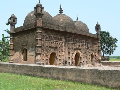
Nayabad Masjid is an architectural vestige. which was built just after the  erection of  Kantanagar Temple. According to local traditions, the mosque was built by Muslim architectural workers who had come to this place from the west to build Kantanagar Temple sometime in mid-18th century. They had settled in Nayabad, a village near the temple, and had built the masjid for their own use.


Before Renovation From Banglapedia 
Location
The masjid is situated on the bank of the Dhepa river in village Nayabad in Ramchandrapur Union under Kaharol Thana of Dinajpur district, about 20 km to the north-west of the district town. The mosque, built on about 1.15 bighas of land, has been renovated by the Department of Archaeology, Bangladesh.


Construction Period
An inscription on the central doorway records the date of its construction as 2 Jyaistha, 1200 (Bangla Calender) (1793 AD) in the reign of Mughal Emperor shah alam II. According to local traditions, the mosque was built by Muslim architectural workers who had come to this place from the west to build Kantanagar Temple sometime in mid-18th century. They had settled in Nayabad, a village near the temple, and had built the mosque for their own use.


Photo by Tanzirian
Architect
It is an oblong three-domed mosque with octagonal towers at the four corners and measures 12.45m ´ 5.5m externally. The walls are 1.10m thick. Of the three arched entrances the central one is bigger than the flanking ones. These are equal in height and width. The central arch is 1.95m high and 1.15m wide. There is an arched window each on the south and north sides. Multi-cusped arches have been used in the doorways and windows. There are three mihrabs inside in the western wall in line with the three entrances. The central mihrab (2,30m high and 1.08m wide) is bigger than the flanking ones which are of equal size. Three hemispherical domes cover the mosque, of which the central one is bigger than the side ones. Pendentives have been used in their phase of transition. The parapet and cornice are straight. 


Of the four corner towers in the four outer corners of the mosque two (northeastern and northwestern) still possess the cupolas on their top. The top of the other two is now bare. The corner towers are plastered and gradually tapering; each had a lantern-like chhatri on the top crowned with a cupola. Four bands at regular intervals decorate the surface of each tower.


Terra cotta
The terracotta plaques used in the decoration of the mosque have become loose and most of them have been damaged. At present there are about 104 terracotta plaques (rectangular in shape, 0.40m ´ 0.30m) used in the surface decoration of the mosque walls. Though damaged some of them show floral and creeper motifs. It is noteworthy that one contains a depiction of a pair of peacocks.


Interesting findings
There is a grave of a person in the premises of the Masjid. There is no proper information about this grave. There is a common rumor that this is the grave of Kalu Khan,the master architect  of Kantanagar Temple. Local people also believe that the masjid was build from the extra materials left after completing the temple.  A madrasa has recently been built in front of the Masjid. Another rumor about the builder is supported by the Daily Star, that this masjid belonging to the second phase development of Islamic period of Bengal was built by Skeikh Mujib Allah who lived in Parganah Nurour during the reign of Mughal Emperor Shah Alam II in 1785 AD (A.H.1200). During that period the Zaminder was Raja Baidyanath, the last of the Dinajpur Raj family.


How to Reach There
One can start his journey for the monument from Dinajpur town or Sayedpur Airport by any kind of motorized vehicle. If he is a biker, than there is no problem. I suggest travelers to hire a rickshaw van of take a ride by 'Nosimon' from the place called 'Das Mile*, which means 10 miles' upto 'Baro Mile*, which means 12 miles' boat point.It may take 10-20 Taka person for ride. 


Travel route from Dasmile to Masjid in Google Map[CLICK FOR LARGE VIEW]
After Reaching Baro Mile point cross the Dhepa River. Travelers will find boatman waiting for crossing the silty river to Kantanagar hamlet. Than just little walk will lead the travelers to the premises of the temple. There is a road to the North Wast side of the temple, which lead the travelers to the Nayabad village, just a 15 minutes walk. Enjoy.
*These places are named base on the distance from Dinajpur Town.
---------------
Mainly compiled from Banglapedia | The Daily Star |  Google Earth KMZ

Kantanagar Temple : The Exuberance of Terracotta Art

Kantanagar Temple : The Exuberance of Terracotta Art
Sundarpur: Kaharole: Dinajpur: Bangladesh
1870's from Wiki


Introduction
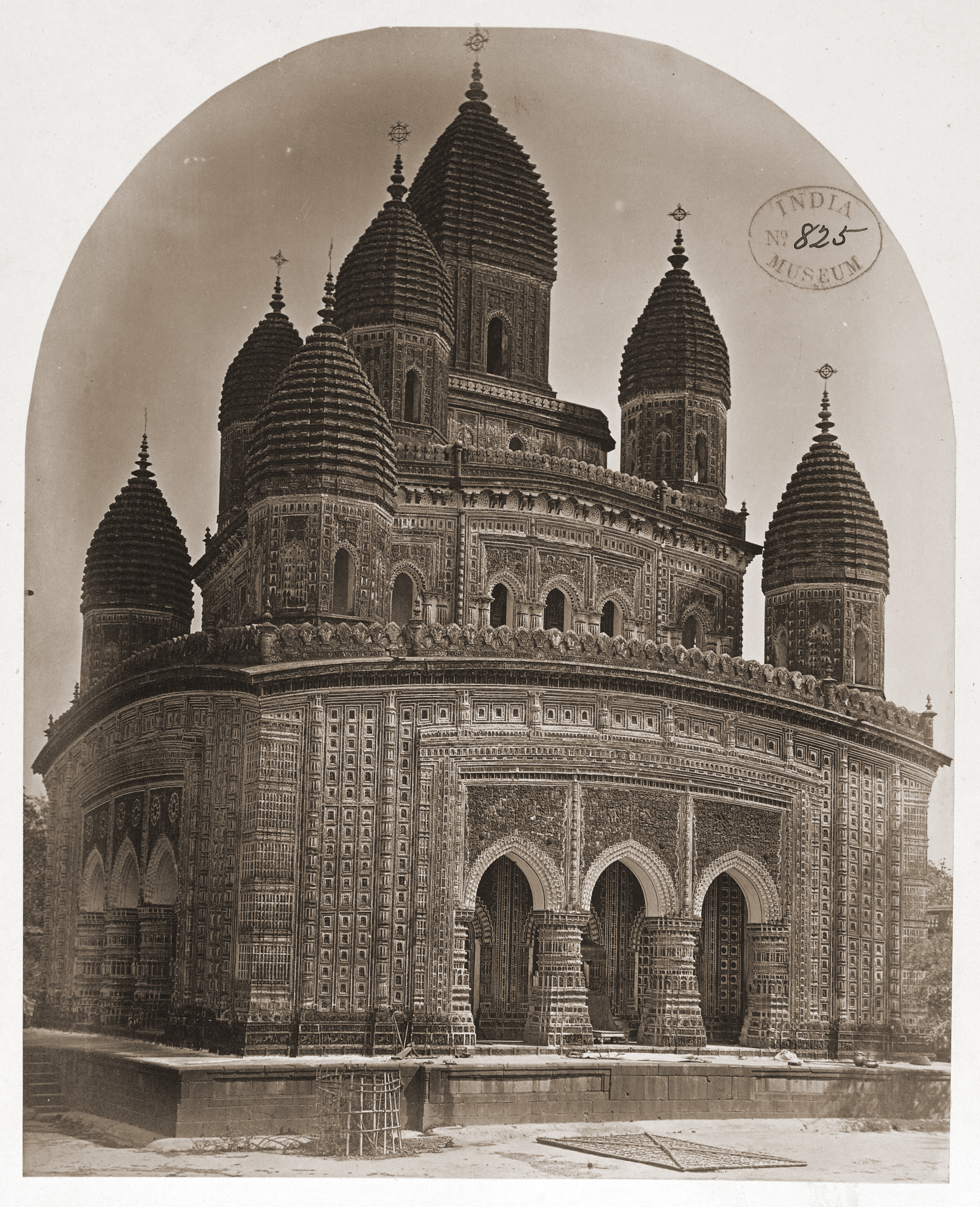
Kantanagar Temple [also known as Kantaji or kantajir Mandir or sporadically titled as Kanta-jiw(jew) Temple], an eighteenth century brick temple situated in the peaceful island hamlet of Kantanagar (Kantanagar), in Sundarpur Union; about 12 miles north of Dinajpur town, and about a mile west of Dinajpur-Tetulia highway across the Dhepa river.It has gained eminence as an outstanding monument in Bengal for its fabulous terracotta embellishment. A breath taking religious edifice belonging to the late medieval period, exhibits the exuberance of terracotta art at its best in Bangladesh. This nava-ratna or 'nine spired' Hindu temple, now stripped off its original nine spires atop its corners during the devastating earthquake of 1897.This temple is listed as world cultural heritage site by UNESCO.


Construction Period 
The confusion about the date of its construction can be settled from the record of a chronogram in the Sanskrit stone inscription, fixed on the northeast corner plinth of the temple. It records that Maharaja Prannath of Dinajpur began its construction about 1722. Bangladesh Archeology Department stated as,"Maharaja Pran Nath built it in 1752" in their website. 


From Banglapedia
It was completed by his adopted son Maharaja Ramnath, in Shaka era 1674 (1752 AD) in order to propitiate the consort of Rukmini in fulfillment of his father's wish. However, in the early 20th century Maharaja Girijanath Bahadur restored it substantially, except for the missing nine spires. The description in front of temple stated the erection of temple during 1704 AD-1752 AD.

Department of Archeology Bangladesh
A Nine Towered Temple
We already know that it was originally a Navaratna (nine- towered) temple, which are now ruined. Every inch of its surface is lavishly decorated with different scenes as described in the two Hindu Great Epics, various Hindu divinities, and contemporary social life and floral cum geometric motifs.
Temple rose in three receding terraces and was crowned with nine ornamental spires or ratnas (jewels) on the corner of the three terraces which imparted to it an appearance of a huge ratha or an ornate chariot resting on a high plinth. It was provided with arched openings on all four sides in order to enable devotees to see the deity enshrined inside from all directions.

Chini Masjid : A 'Chini Tikri' Spectacular

Chini Masjid : A 'Chini Tikri' Spectacular
Location: Saidpur, Nilphamari, Bangladesh

Since the inception of Muslim rulers in this region in 1204, building  masjid in populous hubs become a tradition.Even at present, many Masjids of medieval age are still standing with pride with very rich plinth of architecture,unique terracotta and longevity.Many of this Masjids are still in use for prayer, without any fear of expiration. Most of these Masjids, along with the medieval Mandirs are the main interest of research and exploration for our native archeologist. Day by day the archeological value of these ancient architecture is getting rich.  


Chini Masjid is one of most significant example of archaeological heritage, situated in Saidpur, the northern railway and industrial town of Bangladesh. This masjid was built in 1863. Perhaps the best and renowned masjid for its mosaic work or Chini Tikri art of Decoration.


'Chini Tikri' is art of decoration with mosaic where small chips of Chinaware-plate, and pieces of glass(both color and non color) porceline, lends and jewels  used as materials. Most of the Historic Masjids that were built in age of Mughals in Bengal(1576-1757)are the best examples of this type of decoration culture.


Chini Masjid is the latest decor and significant example of such mosaic fabrication. This  seemingly improbable masterpiece  was built in one year. Entire complex, both interior and outside including minarets and domes is fabricated, only the floor of the compound is  left untouched for any  artwork.
----------
Just Look AroundGoogle Earth KMZ | Panoramio Pixes

World's last Island-Prison : Coiba

I made this post as reply of an incredible prison collection in 2009. Now I am going to share it in this blog. Readers may find many content about this prison in web, because it is a popular place. 
......................................
World's last Island-Prison : Coiba
Coiba - an island of Panama, once known as the devil's island, is the last prison island on the globe.
The island was made a penal colony in 1919 and played host to some 1.000 prisoners every year that spread over several prison camps. During the years that Panama was under the Dictatorships of Omar Torrijos and Manuel Noriega, the prison on Coiba was a feared place with a reputation for brutal conditions, extreme tortures, executions and political murder. 


Nobody knows exactly how many people were killed in the prison during this period, but sources claim that the number could be close to three hundred. As such, the island was avoided by locals, and other than the prison, was completely undeveloped.


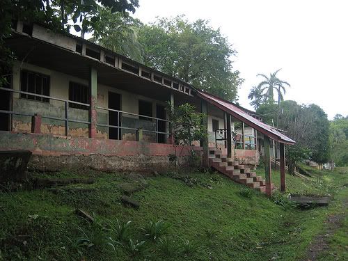
Coiba Prison : Present situation of a penal colony
pix by : Alan Meiss from Flickr

Until the beginning of this year a few hundred prisoners still live in Coiba. They used to hunt and fished for their own food. The grew vegetables and took care of some livestock. Most of them lived in huts built by themselves in camps all over the island and spend years without seeing their families. The could move out around the camps, go to the rainforest or even swim in the ocean, and no lock huts were used at the beach camps.
Coiba Prison : Pix by : J.Pellice from Panoramio

The prison is now closed. The prisoners have been relocated to other facilities and anything of value has been removed from the site. The remaining structure is slowly being reclaimed by jungle and the marine air.The island was declared a National Park in 1992.UNESCO declared the entire Coiba National Park a "World Heritage Site" in July 2000
...........................................

Neer Mahal : The Water Palace of Tripura

I never go here but wish to go, one day. This palace caught my eye, when I was flying over Tripura's(India) sky in Google Earth. after a little search work in internet , I find some good history. This place may be take place in blogger's world, though I can't wait to share my view to let people know about this place. 


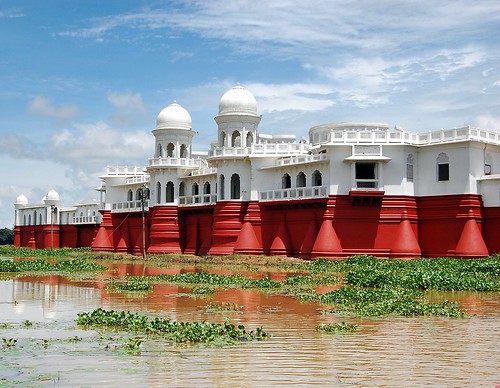
Neermahal,where 'Neer' means water, the water palace, built in 1930 by Maharaja Bir Bikram Kishore Manikya as summer resort is located at a distance of about 53 km from Agartala. The second water palace in India(first one is in Rajshtan). The palace, which took nine years to be built, is a pleasing harmony of Hindu and Muslim architecture. Over 400 feet in length, the palace contains two distinct wings - eastern one is for housing security and menial staff and the western wing is reserved for roayaly and the extended royal family.


Image Courtesy : Kanad Sanyal from Flickr
.................................................................................................................

History of Conception

To come to the story of palaces in the centre of a lake, there was a king by the name of Bir Bikram Kishore Manikya. His fantasy too was similar to that of King Ludwig.King Ludwig II built a palace of beauty par excellence in the middle of lake Chemisee in the Bavarian country.The two kings are compared because both of them had enough places to stay in without requiring a palace in the centre of a lake and they both built it for the sake of doing so. While Ludwig is said to have planned his palace with an intention to make money by encouraging visitors to his castle, the king of Tripura did not have any such pretext. He was just indulging himself.


The Palace inside

It took nine years to build a structure that appeared to be a floating castle. With 24 rooms, the palace is 400m long. The palace can be divided into two main sections: the Andarmahal, which is to the western side and the eastern side, which was meant to house the staff of the king. In the main building were two sections one for the king and one for the queen with a huge dancing room is lined with five rooms: a bathroom, a leisure room, a bedroom and treasury room and a room for playing chess. In addition to this, the queen's friends and relatives had a set of six rooms for themselves while the king and his men had another set of rooms of which one is a large meeting hall, where he met the masses.There is a huge garden inside the palace, leads the western wing - the Andermahal of the palace. At night, flood lighting add colour to the beauty. In winter large number of migratory birds are seen in Rudrasagar Lake surrounding the palace.Besides the fishermen's activity in lake is also an eye catching subject. There are two option to get in - the Maharajah Stairs and the Maharani Stairs.


...........................................................................................
Those who are not in hurry to go there,
may love to take a glimpse. The following tube may be an interesting one : 
-----------
Web Source : Indiainfoweb, Wikipedia
For Google Earth view Click Here<< | Google Map

Bhitargarh : 1500 Years Old Buddhist Monastery

I went to Bhitargarh in 2004, the academic tour from my University. Recently I take another trip there.  I did a little study that time for preparing my study tour report. I quote some text from Banglapedia here, but the description in banglapedia is not enough for curious readers, if one does not go there and see it by his own eyes. I suggest - rainy season is the best time for travel to that place. Now I feel people should know about this place, so here is my little attempt to let people know about this interesting place of northern most district of Bangladesh. 
..................................................
Relative Location
Bhitagarh Fortification,built in the sixth or the seventh century, 16 kilometres south of the Panchagarh town, is under Amarkhana union of the district sadar upazila,this place is the biggest fort city of Bangladesh.
.................................................
Brief History 
Bhitargarh Fort  formed a part of the chain of early medieval mud-forts erected mostly by the Muslim rulers at different times to defend their territory against the incursion of their northern Hindu neighbours. The territory east of the Karatoya River was for sometime a part of the Ahom kingdom. In the15th century this area was included in the Tibeto-Barman Khen dynasty's territory and served as a sort of buffer state between Assam and the Muslim Kingdom of Bengal.


"The existence of fifteen garhs (fortifications) has hitherto been traced of which the most noted are Bhitar Garh, Hosain Garh, Mir Garh, Rajan Garh and Deven Garh. Panchagarh is named after these five garhs. Amongst these fortification Bhitargarh is still vigilant archeological site. Total Garh is bounded by both manmade and natural canal and fort like wall."-Banglapedia.

Bhitargarh fort city, established in the sixth or seventh century, had a sovereign administration. Built on important trade routes, the fort city had trade links with Tibet, Bhutan, China as well as with West Bengal, Bihar, Sikkim and Punhdrabardhan of India.

.................................................
The entire fort city is bordered by two rectangular wall- inner and outer wall or fortifications. There are two villages inside the wall- Bhitargah and Maharajar Hat, with village market (Bhitargarh bazar ).Most interesting feature is the Maharajar Dighi. Which is a large pond,the most attractive place inside the fortification. It is really beautiful during rain. Probably the Maharaja(king) of Bhitargarh, dug the canal for supplying sweet water inside the fort. the pond might be connected by drainage network. 
.................................................
Recent Findings
The fortification is now the most important archeological site of the country. The place comes to spot light after a recent excavation program , which has been uncovered some 200 archeological site inside the fort city.


The site shown in image, is assumed to be the royal buddist monastery , loacated beside the ruins of KACHARI(administrative building for collecting tax and ravenue) of Maharaja;s Palace 
Among these sites , there are several temples and buddist Stupa has been discoverd. Archeologists hope to discover the biggest Buddhya Bhiara in the most northern region of Bangladesh.Samples collected from the sites are significantly different from those of Paharpur and Mainamati Bhihara. It is also assumed that the bhihara and its surrounding could be bigger than Mainamati Buddhist Bhihara.
This biggest fort city had a sovereign administration. Built on important trade routes, the fort city had trade links with Tibet, Bhutan, China as well as with West Bengal, Bihar, Sikkim and Punhdrabardhan of India.

Here is Youtube video in Bagnla, with some good footage:


-------------------------


News and Image Source : The Daily Prothom-alo | The New Age | ULAB
For Google Earth View Click Here<< ,In Google Map

Related Posts Plugin for WordPress, Blogger...